
Where is Dholavira located is one of the most common questions asked by people interested in India’s ancient history and the Indus Valley Civilisation. Dholavira is one of the most important archaeological sites in South Asia and offers deep insight into how early urban life developed thousands of years ago.
Introduction to Dholavira
Dholavira is a well-preserved ancient city that belonged to the Indus Valley Civilisation, also known as the Harappan Civilisation. It is famous for its advanced town planning, massive water management system, unique architecture, and long stone inscriptions.
Among all Harappan sites discovered so far, Dholavira stands out because of its size, planning quality, and remarkable engineering skills. Today, it is recognized as one of India’s most valuable heritage sites and has been declared a UNESCO World Heritage Site.
Understanding where is Dholavira located helps us better understand the geographical spread and brilliance of the Indus Valley people.
Where Is Dholavira Located
Where is Dholavira located can be answered clearly in geographical terms. Dholavira is located in the Kutch district of the Indian state of Gujarat.
More specifically, it lies on Khadir Bet Island in the Great Rann of Kutch. This island is surrounded by seasonal salt marshes that remain underwater during the monsoon and dry up in summer.
Dholavira is positioned between two seasonal streams called the Mansar and the Manhar. These natural water channels played a major role in the city’s survival in an otherwise dry desert region.
The exact location of Dholavira places it in western India, close to the India–Pakistan border, in one of the most environmentally challenging regions of the subcontinent.
Geographic Details of Dholavira
Dholavira’s location is unique because it sits in a semi-arid region with extreme temperatures. Summers are very hot, winters can be cold, and rainfall is extremely limited.
Despite these harsh conditions, the ancient people of Dholavira created a thriving urban center by mastering water conservation techniques.
The city was strategically built on elevated land to protect it from flooding during monsoon seasons. The surrounding flat land made it easier to plan large-scale construction and reservoirs.
This geographic choice shows the advanced understanding of environment and engineering possessed by the Harappan people.
Dholavira Location on the Map of India
If you look at a map of India, Dholavira is located in the northwestern part of Gujarat.
It is approximately:
- 250 kilometers from Bhuj
- 400 kilometers from Ahmedabad
- About 85 kilometers from the nearest town, Rapar
The site is accessible by road and lies deep inside the Rann of Kutch region, making the journey both scenic and historically fascinating.
Knowing where is Dholavira located on the Indian map helps travelers and researchers understand why this site played a major role in ancient trade networks.
Historical Importance of Dholavira’s Location
The location of Dholavira was not chosen randomly. It held great strategic value in ancient times.
Dholavira stood along important trade routes connecting:
- Gujarat’s coastal ports
- Sindh region
- Rajasthan interior
- Mesopotamian maritime routes
Its position allowed merchants to move goods such as beads, copper, shells, and semi-precious stones.
Being close to the Arabian Sea, Dholavira maintained trade connections with distant civilizations, including Mesopotamia. This explains why seals and artifacts found here show international influence.
Dholavira and the Indus Valley Civilisation
The Indus Valley Civilisation flourished between 2600 BCE and 1900 BCE. Major cities included Harappa, Mohenjo-daro, Lothal, Kalibangan, and Dholavira.
Among these, Dholavira is one of the five largest Harappan sites discovered so far.
Unlike many other sites, Dholavira shows continuous occupation for nearly 1,500 years. Its location in Gujarat proves that the Harappan civilisation was not limited to present-day Pakistan but extended deep into western India.
This makes the answer to where is Dholavira located extremely important for understanding ancient Indian history.
Discovery of Dholavira
Dholavira was discovered in 1967 by archaeologist Jagat Pati Joshi of the Archaeological Survey of India.
Systematic excavations began in 1990 under the leadership of R. S. Bisht. Over several decades, extensive remains were uncovered, revealing the city’s full grandeur.
Because of its isolated location in the Rann of Kutch, Dholavira remained untouched for centuries, which helped preserve its original structures remarkably well.
City Planning and Urban Layout
Dholavira’s city planning is considered one of the finest examples of Harappan architecture.
The city was divided into three main parts:
- The Citadel
- The Middle Town
- The Lower Town
Each section was protected by massive stone walls. This division is unique among Harappan cities and shows strong administrative organization.
Wide streets, well-planned drainage, large public spaces, and standardized construction techniques demonstrate an advanced understanding of urban design.
Water Management System of Dholavira
One of the most remarkable features of Dholavira is its water management system.
Due to its dry location, water conservation was essential for survival. The city contained:
- Large stone reservoirs
- Step wells
- Rainwater harvesting channels
- Underground drains
These reservoirs collected rainwater flowing from nearby hills and streams.
This engineering achievement proves that the people of Dholavira were far ahead of their time in sustainable water use.
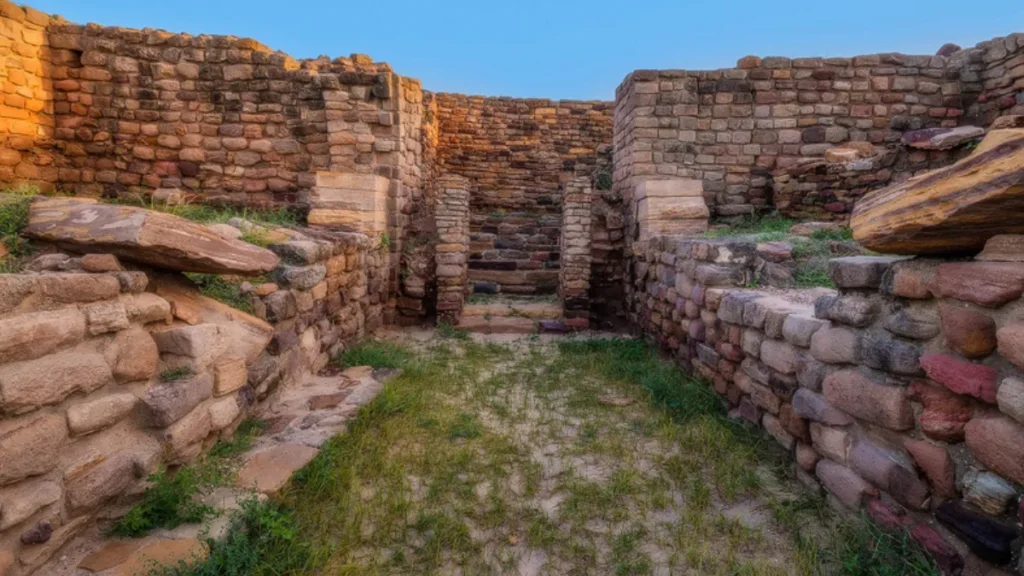
Architecture and Construction Materials
Unlike many Harappan cities built mainly with bricks, Dholavira used locally available stone.
The buildings, fortification walls, gateways, and reservoirs were constructed using dressed sandstone blocks.
This stone-based architecture makes Dholavira visually different and stronger than other Indus Valley cities.
The durability of these structures is one reason why so much of the city remains visible even today.
The Famous Dholavira Signboard
One of the most important discoveries at Dholavira is a large signboard containing Indus script symbols.
The inscription was made using white gypsum pieces fixed onto a wooden board.
It is considered the world’s oldest known signboard and possibly indicated the city’s name or administrative authority.
This discovery adds immense value to understanding early writing systems.
Cultural Life in Dholavira
Excavations reveal that people in Dholavira lived a well-organized and culturally rich life.
Artifacts found include:
- Pottery with geometric designs
- Gold and silver ornaments
- Beads made from carnelian and agate
- Tools and seals
The presence of stadium-like structures suggests that public gatherings, ceremonies, or games may have been held there.
All these findings show that Dholavira was not just a trading center but also a cultural hub.
Decline of Dholavira
Like other Indus Valley cities, Dholavira declined around 1900 BCE.
Several reasons are believed to have contributed:
- Climate change
- Declining rainfall
- Shifting river courses
- Repeated droughts
As water sources dried up, sustaining a large population became impossible.
Gradually, people migrated to regions with better agricultural conditions.
UNESCO World Heritage Site Status
In 2021, Dholavira was officially declared a UNESCO World Heritage Site.
This recognition was given due to:
- Outstanding urban planning
- Advanced water conservation system
- Architectural uniqueness
- Historical significance
The global recognition has increased awareness about where is Dholavira located and its importance to world history.
Tourism at Dholavira
Today, Dholavira is one of Gujarat’s most important heritage tourism destinations.
Visitors can explore:
- City walls
- Reservoirs
- Gates and streets
- Excavated structures
The peaceful desert surroundings add to the site’s charm.
The Gujarat government has developed visitor facilities while preserving the original ruins.
Best Time to Visit Dholavira
The best time to visit Dholavira is between October and March.
During these months:
- Weather remains pleasant
- Roads are accessible
- The Rann of Kutch landscape is beautiful
Summer temperatures can be extremely high, making travel difficult.
How to Reach Dholavira
Dholavira can be reached by road from major cities of Gujarat.
The nearest railway station is Rapar, while the nearest airport is Bhuj.
From Bhuj, travelers can hire taxis or use state transport buses to reach the site.
The journey through the salt desert offers a unique travel experience.
Also read: Dholavira Gujarat: The Lost Stone City of the Indus Valley Civilization
Why Dholavira’s Location Matters Today
Understanding where is Dholavira located helps historians, archaeologists, and students appreciate how ancient civilizations adapted to difficult environments.
The city proves that advanced urban societies can thrive even in deserts through intelligent planning and sustainable practices.
Dholavira’s location also highlights India’s role in early global trade and technological innovation.
Also read: Dholavira: Complete History, Discovery, Civilization, and Importance
Conclusion
Where is Dholavira located is more than a simple geographic question. Dholavira is located on Khadir Bet Island in the Great Rann of Kutch in Gujarat, India, but its importance reaches far beyond its physical position.
It represents human resilience, engineering brilliance, and cultural excellence from over 4,500 years ago.
Today, Dholavira stands as a powerful reminder of India’s ancient heritage and continues to inspire researchers and visitors from around the world.
By understanding its location, history, and achievements, we gain a deeper respect for one of the greatest civilizations in human history.